“I take to the open road. Healthy, free, the world before me.” –Walt Whitman
Let’s go. The northwestern Wisconsin summer had succumbed to the dog days of August. Flowers continued to bloom at our happy place, Northern Bliss, but the lakeshore was beginning to look a little drab. Water lilies faded. Ferns and hostas curled and turned brown at the edges, recoiling from the heat. I felt that I might shrivel too if I hung around much longer.
I turned to Gunter, my soulmate, travel companion, and best friend. (He also happens to be my husband.) “The gardening’s all caught up—finally. The housework—well it’ll still be here. It’s not going anyplace. So let’s just take off and go.”
“Where?” Gunter asked, raising one eyebrow to show he was really listening.
“Cornucopia.”
“And what is that? Sounds like something you’d use as a Thanksgiving centerpiece.”
“It’s a town. On Lake Superior. My gardener told me about it.”
“Have you been there before?”
“No. That’s why I want to go. Adventure is out there. The freedom of the open road and all that.”
Gunter leaned forward in his recliner. That was a good sign. I pressed my advantage.
“It’s close to Bayfield, and I have been there. That town is the launching point for the Apostle Islands, where I learned to sail.
“A piece of your history I don’t know about. Hmm. Could be interesting.”
“We could take a car ferry to the largest of the Apostles, called Madeline Island,” I proposed. “I haven’t done that, because our Sailing Club rented boats and departed right from the Bayfield marina.”
Gunter warmed up to the idea, so we blocked three days off our calendar—Monday-Wednesday, August 10-12—for which we had no commitments. Basically, we would need to book a safe place to stay for two nights. Other than that, we’d play it by ear, keeping to the back roads of rural Wisconsin as much as we could, stopping at small towns along the way. Gunter and I embrace the concept of slow travel; we like to make memories instead of rushing to destinations. That way, we can expect the unexpected.
We’d be traveling across Northern Wisconsin from west to east, through counties in which COVID-19 fatalities were in the range of 0-10. (Our county, Polk, has only two fatalities since March so we’ve become accustomed to low numbers; here we have a .005% chance of dying from this disease. We didn’t want to increase our risk. My task was finding a hotel or B&B that had safe procedures in place. Through my internet search, I came across Timber Baron Inn, a secluded forest get-away that serves up to eight guests. Breakfasts would be delivered to the rooms and they maintain strict cleaning policies. Bingo!


We set out to drive the rolling hills and lush green valleys of Wisconsin under a cobalt blue sky and puffy white clouds—a perfect morning with temps in the low seventies. Our SUV was stocked with a well-balanced diet of caffeine, salt, and sugar. We would stop along the way for “real food.”
Spooner. Our first stop was the town of Spooner in Washburn County. At the River Street Family Restaurant we enjoyed a late breakfast of bacon, eggs, and homemade potato fries. There was not a mask in sight! Spooner, with a population of 2700, calls itself the Crossroads of the North, because Hwy 53 and Hwy 63 meet there. But in the past, it was a busy railroad hub. The Wisconsin Great Northern Railroad still operates a historic train line centered in Trego on 26 miles of track, between Spooner and Springbrook. The Railroad Memories Museum, unfortunately, was closed due to COVID. We stopped at a wood-carving museum instead where we garnered advice about putting a bear statue atop our high oak tree stump.
Hayward. From there, we followed the Namekagon River, part of the St. Croix National Scenic Riverway, to Hayward, Wisconsin, 2300 population. The county seat of Sawyer County, Hayward is best known for its chain of fishing lakes. It is home to the National Fresh Water Fishing Hall of Fame. That facility contains a 143-foot (44 m) musky, the world’s largest fiberglass structure. It is also known for the Lumberjack World Championships, an event I attended one summer with Gunter and his sister Helga.
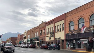
Ashland. Our next stop was Ashland, Wisconsin, 50 miles away on the shores of Lake Superior. This port city of 8200 is known as the Historic Mural Capital of Wisconsin, where the ghosts of the past appear in living color. Strolling through Ashland’s lively business district was a treat: I loved walking past all the old brick and brownstone buildings—still open for business. Along the way, we stopped to view more than a dozen murals depicting the city’s history.
Ashland has been a working trade town, ever since French fur traders Radisson and Chouart landed on its shores in 1659 and built a shack that became the first European dwelling in Wisconsin. Two hundred years later, Chequamegon Bay was filled with rafts of cut timber and boats ferrying locally quarried brownstone to the cities in the east. Later, when the Upper Peninsula’s Gogebic Range began producing iron ore, freighters carried it out of Ashland’s docks. Now, none of those docks remain.
Before leaving town, we filled up at a rare gas station—with a beach. Lake Superior stretched out in front of us, for as far as the eye could see. This magnificent lake is the largest of the Great Lakes of North America, the world’s largest freshwater lake by surface area (31,700 square miles), and the third largest by volume. There, we sauntered along the Lake Superior shoreline, stopping occasionally to photograph sun-struck, red-iron boulders and wave-weathered driftwood. Afterward, we sat there for a while, thinking about that busy port of long ago. I turned toward Gunter. “This lake looks calm right now. But did you know that she’s dangerous? She caused about 350 shipwrecks and she’s known for keeping her dead in the deep? I had his attention. “Yes, over 10,000 lives have been lost in these waters.”

Lakeshore, Superior.

Lake Superior boulder.
During a road trip in America, one must down at least one big burger. We fulfilled that goal on the way from Ashland to Bayfield. I picked up my burger so Gunter could take the photo. I tried to take a bite, but it wouldn’t fit into my mouth!

Big Burger.
We drove through the town of Washburn and followed the GPS where it said to turn, three miles south of Bayfield to Ski Hill. I could understand how this road got its name! We drove up and up and up, to the foot of Mt. Ashwabay, and took a left onto a long dirt driveway. There it was—The Timber Baron Inn, our secluded forest getaway. Through the trees, one could see the waves of Lake Superior dancing under the sun.

Ski Hill.
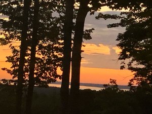
Sunrise view through our window.
Tuesday morning, we could have slept in. We knew that the first departure of the Madeline Island Ferry was not until 9:30 a.m. But at 6:30, a gorgeous sunrise beamed through our sheer curtains, daring us to join the day. Gunter went for coffee in the lobby and by 7:30, our breakfast tray arrived filled with goodies: scrambled eggs, sausage, blueberry scone, and yogurt-with-granola. That could fuel us for the entire day!

Our breakfast platter.
Bayfield and Madeline Island. The town of Bayfield—with a population of 500 and many times that during tourist season—is a popular resort, yachting, and vacation destination. It is also known as a lumber and commercial fishing town. But to me, this town has always been the gateway to the Apostle Islands National Lakeshore, the group of islands where I learned to sail. These islands are a national treasure, with lighthouses, sea caves, and some of the best kayaking in the world. The year 2020 marks fifty years as an official National Lakeshore. You can take a virtual tour here that includes a hike around Stockton’s Julian Bay and Raspberry Lighthouse, one of nine lighthouses within this national park.
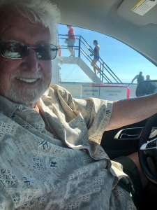
Gunter at the wheel while on the car ferry.

View of Bayfield Old Mansions from ferry.

Bayfield Yacht Club as seen from ferry.
The process of taking the car ferry on the 3-mile trip from Bayfield to Madeline Island, the largest of these islands, went like clockwork and soon we were driving through the quaint town of La Pointe. Unfortunately, the museum was closed but as we drove, we came upon a garden store with gnomes and fairy garden figures. These would be our souvenirs of the island. After that stop, it was time to find some nature. The island is home to Big Bay State Park and Town Park. Since we would only be there for the day, we chose the Town Park rather than buying a sticker. We were not disappointed! A conifer-lined walking path took us down over a bridge to an islet with a wonderful sandy beach and fantastic views. We sat on a log and took off our shoes. I dipped in a toe, then my entire foot, and then walked in up to the hem of my shorts. Brrr! It was then I realized that only children were in the water. The parents—those wimps—sat watching them from their portable chaise-lounges on the sandy beach! It was then that I remembered another statistic: The average temperature of Lake Superior is 36ºF, 2ºC.

Madeline Island road sign.

Testing the water.
Back in Bayfield, we enjoyed smoked lake-trout salad for a late lunch and purchased more smoked lake fish to take home.

Smoked Lake Trout Salad.
“This was nice, but I look forward to Cornucopia,” Gunter said as we left Bayfield.
Washburn. We returned to The Timber Baron for a rest and then drove further south to the town of Washburn (population 2200) for dinner. We stopped for made-to-order pizzas at Dalou’s Bistro & Wood Fired Pizza Oven. Mine was one of the best pizzas I’ve ever had! We preferred the laid-back, hometown feel of Washburn to tourist-filled Bayfield. After our dinner, we discovered a local city park where we watched the sun set over Lake Superior—just the two of us—along with a group of friendly seagulls.

Dalou’s Bistro.
Cornucopia. “I want to finally see Cornucopia!” Gunter said during our second home-cooked breakfast at The Timber Baron. He was practically jumping up and down.
I laughed. “Today’s the day.”
We plugged our destination into the GPS. It was not a straight route. We didn’t mind the scenery, even though the track took us inland from Lake Superior most of the time. But when we hit detours and then a miles-long stretch of road construction, we both grew impatient. A supposedly-27 minute drive stretched to two hours. Finally, the official green sign came into view. “Cornucopia!” we shouted in unison. A mile later, we spied another sign. This one contained a drawing of huge cornucopia right in the center—just like the Thanksgiving centerpiece Gunter had envisioned.
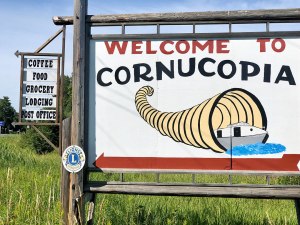
Welcome to Cornucopia sign.
On our way into town, we spied at a rest stop—if you could call it that—with one picnic table under a colorful wooden pergola. We pulled off the road into a sandy parking area large enough for about five cars. We followed a nature path to a deserted sandy beach, complete with two worn Adirondack chairs. We walked the narrow beach for a while, stepping over more weathered logs and gray driftwood. As we returned to our SUV, another vehicle pulled in. A family of five poured out, each carrying his or her own container, promptly pumping the handle an artesian well. “Oh, that’s what this stop is for,” Gunter muttered. “Wish we had a container.”
We drove toward a small marina, with working fishing boats, surrounded by a few cute tourist shops. “Stop!” I demanded. “This must be where the Siskowit River meets Lake Superior. “They’re bound to have some shops there.” The harbor was quaint and picturesque, old fishing boats and quaint shops reflected in clear water. But I was disappointed to see that they were all closed with “Due to COVID” signs. We never met a soul.
Further on, we saw a commercial fish factory. That was open! We purchased smoked whitefish, all cut up and deboned for a salad, and loaded up on ice for our cooler. It felt wonderful, just to talk with someone! Outside, we found unlocked, public restrooms. Hooray!
Expect the Unexpected. Surmising that was the town, we were more than a little disappointed. But as we drove on, we noted that the business district was off the main drag. There was more! There we found “Wisconsin’s Northern Most Post Office,” Ehlers General Store, a large brick building that could be the town hall, one café, and a few businesses fronting two sides of a wide, paved street.

Little Nikki’s Restaurant.

Ehlers Store.
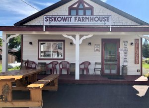
Siskowit Farmhouse.
Beyond that, the road led to the Siskowit River waterfalls my gardener had raved about. We ventured down a path to the lower falls, but it was dark, with fleeting river views between the foliage, and full of mosquitoes. The best photo op was from the gravel road that crossed the wooden bridge. There the upper falls dropped energetically from a ledge in the stream to a twelve-foot-wide sparkling pool of foam. We sat there for a while and ate one of our salty snacks.
“So this is Cornucopia.” I said. “A population of only 100 souls.”
“Pretty in its own way,” Gunter volunteered.
“Yes, it is. Just not what I expected.”
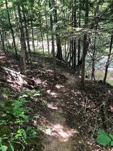
River walk alongside falls.

Siskowit Falls, Cornucopia.
Road trips are the equivalent of human wings. Ask me to go on one. Anywhere. We’ll stop in every small town and learn the history and stories, feel the ground, and capture the spirit. Then we’ll turn it into our own story that will live inside our story to carry with us, always. Because stories are more important than things.
–Victoria Erickson
About the Author: Lois and Günter Hofmann lived their dream by having a 43-foot ocean-going catamaran built for them in the south of France and sailing around the world. Learn more about their travel adventures by reading Lois’s award winning nautical adventure trilogy. Read more about Lois and her adventures at her website and stay in touch with Lois by liking her Facebook page.